| In Short |
| Hurricane Francine is intensifying in the Gulf of Mexico, heading toward Louisiana for a late Wednesday landfall. |
| Louisiana’s coast faces a dangerous storm surge of 5-10 feet, with extensive flooding expected. |
| Record-warm Gulf waters are fueling Francine’s rapid intensification, possibly reaching Category 1 hurricane status. |
| Heavy rainfall across the Gulf Coast could lead to flash flooding and widespread power outages. |
| Residents are urged to prepare immediately and stay informed through official updates. |
Louisiana is bracing for a potentially catastrophic landfall as Hurricane Francine intensifies in the Gulf of Mexico, expected late on Wednesday. The by-now forceful hurricane, which had formed over the Bay of Campeche as Tropical Storm Francine, began to take shape and threatens the Gulf Coast with life-threatening storm surges, high winds, and heavy rainfall.
The National Hurricane Center has issued Hurricane and Storm Surge Watches for a large part of the Louisiana coastline, as Francine draws near. As the region is one of the easily prone areas in severe weather conditions, flooding, among other catastrophes, residents are advised to plan for the worst.
The Rapid Intensification of Francine
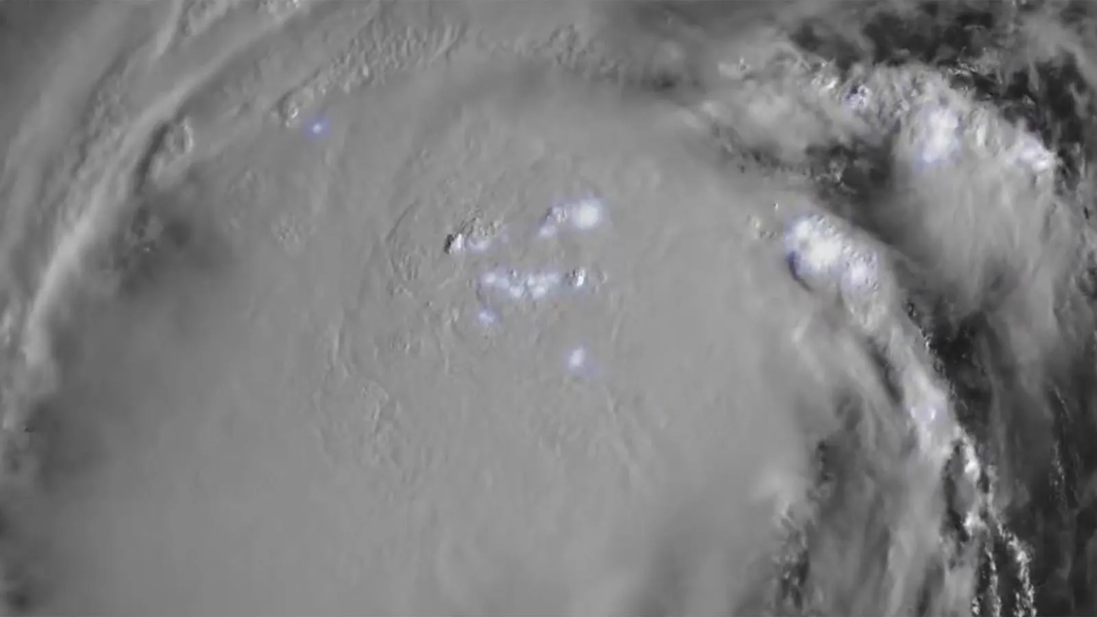
Hurricane Francine has strengthened rapidly since developing over the record-warm waters of the Gulf of Mexico. Currently, Francine is about 480 miles south-southwest of Cameron, Louisiana, crawling north-northwest at 5 mph (8 kph). As of the last advisory, the storm has sustained winds of 50 mph (80 kph), with a central pressure of 1002 mb.
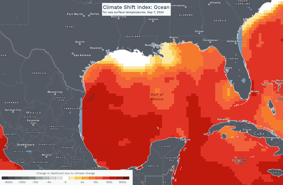
Francine’s passage across the Gulf has been characterized by an increasingly organized structure with the heavy thunderstorm core growing in size and displaying impressive lightning activity. The system is likely to strengthen further before landfall and could attain Category 1 hurricane strength. Conditions in the Gulf are nearly ideal for rapid intensification, with sea surface temperatures of 31°C (88°F) and very light wind shear.
The Threat of a Dangerous Storm Surge
Of the most dangerous elements of Hurricane Francine, perhaps the most troublesome could be storm surge, should it happen along the Louisiana coast. Current forecasts show a storm surge may reach 5 to 10 feet in places near and to the east of where Francine’s eye crosses the coast at 1.5 to 3 meters. This surge may inundate large areas, especially those that are in areas that are so extremely low lying or subjected easily to flooding.
Off the coast of Louisiana, the waters are shallow, so it enhances the surge effect. This might turn the region into one of the most susceptible in the entire world to storm surges. A surge of this order has potentials to occasion extensive property destruction, erosion of coastlines, and disrupted infrastructures of the core.
Projected Path and Timing
The latest forecast track of Hurricane Francine indicates that landfall along the central Louisiana coast is likely with the most significant impacts expected in the vicinity of Cameron and surrounding areas. However, there is still some uncertainty with regard to the exact location and time of landfall, with current model runs indicating a late Wednesday afternoon to early Thursday morning window.
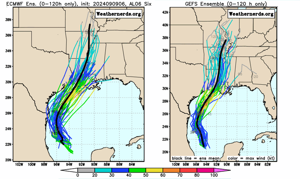
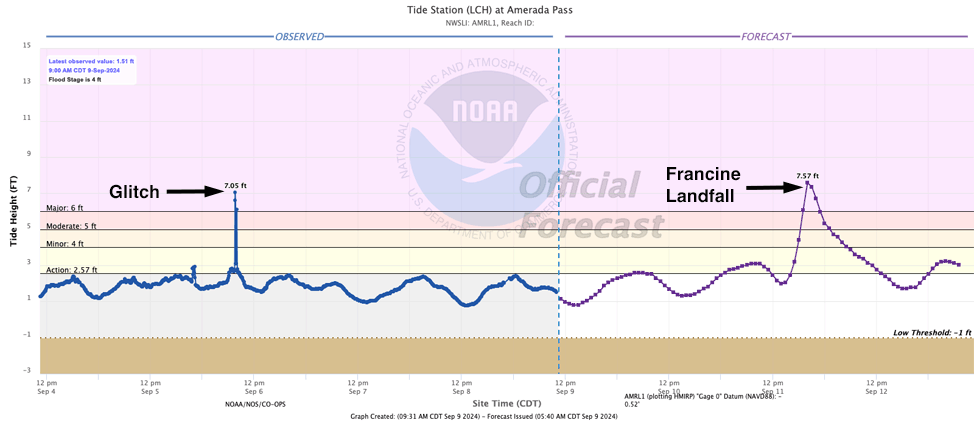
This is particularly critical because the time of landfall will coincide with tidal cycles. The high tide at Amerada Pass in central Louisiana is early Thursday morning at 3:30 a.m. EDT, and a landfall during that time could be especially problematic for coastal flooding as a result of the storm surge and high tide combined.
Louisiana Prepares for Impact
As the hurricane approaches closer, all the local authorities in the state of Louisiana began their preparations in order to reduce the magnitude of the damage that this storm will bring. Evacuation orders may be given to some of the most sensitive coastline areas, while people are asked to prepare their homes and stock food and other essential supplies in advance.
State emergency management agencies continue to closely monitor the development of Francine, while remaining in constant coordination with federal agencies headed by FEMA for prompt response, should wide-scale damage occur.
Potential for Heavy Rainfall and Inland Flooding
In addition to the storm surge, Hurricane Francine is forecasted to bring torrential rainfall across a wide swath of the Gulf Coast, from northeastern Texas to coastal Alabama. Locals could see rainfall totals over four inches, portending flash and riverine flooding during the passage of this system, particularly among those areas that have already been saturated by earlier rains.
With this hurricane heading inland, strong winds together with heavy rain could bring about widespread power outages, fallen trees, and other infrastructure damage that makes recovery efforts difficult.
What’s Next for Hurricane Francine?
It will be fighting increasing wind shear and drier air as Francine approaches land, which might limit additional intensification before landfall. However, even a strong tropical storm or Cat 1 hurricane can result in significant damage-particularly to places unprepared for such impacts.
Residents along the Gulf Coast should monitor updates from the National Hurricane Center and local authorities for further updates because the forecast is subject to rapid change. In summary, residents should complete preparations as soon as possible in preparation for safety from the storm.
The approach of Hurricane Francine toward Louisiana is a great peril on the Gulf Coast. Residents in the areas that the hurricane may strike should, out of this, take all precautions to avoid loss of life and property in case it brings in dangerous storm surge, heavy rainfall, and high winds. This need for information and preparedness cannot be gainsaid as development in the sequence of events that would lead to mitigating the impact of the hurricane.
For Latest News Updates, Click Here.